Independent Report Confirms Uranium Discovery and Expansion Potential at Angilak - Highlights 31 KM Rib-Nine Iron Trend With Grades up to 30.3% U3O8 & Mushroom Lake With Grades of up to 47.8% U3O8 in Outcrops
HIGHLIGHTS
The Angilak Project is situated around the Angikuni Basin, which is a direct analog to the Athabasca Basin with comparatively little exploration. The Project is anchored by the Lac 50 Deposit in addition to eight named showings containing high-grade uranium located across the project area;
SRK Consulting completed regional scale Structural Interpretation and Targeting Assessment that identifies the major primary and secondary structural controls (conduits, traps, and the overall plumbing system for uranium) hosting the majority of high-grade mineralized discoveries beyond the Lac 50 Deposit area at the Angilak Project located in Nunavut, Canada;
Understanding these controls provides the Company with a roadmap for targeting additional discoveries, such as unconformity and basement - Athabasca style - high-grade uranium mineralization within the Angikuni Basin;
Rib-Nine Iron Trend:
Increased from 25 to 31 km and is now interpreted to extend under the cover of the Angikuni Basin;
Along the Eastern margins outcrops with historic (2014) samples proximal to the Nine-Iron Discovery with grades up to 30.3% U3O8 have been discovered on surface, these showings have not been drill tested at depth;
Along the Western margin, historic drilling at the RIB Discovery intersected shallow (1% U3O8;
Numerous similar structural targets have now been identified along this trend, extending under the cover of the Angikuni Basin;
Mushroom Lake Outcrop and Lac 50 Deposit:
The report interprets that the Angikuni Shear Zone and secondary extensional structures transect the Lac 50 Deposit area and correlate with the Mushroom Lake Outcrop;
These secondary structures act as the controls and host high-grade uranium;
Outcrop samples at Mushroom Lake from historic samples have returned grades of up to 47.8% U3O8;
The Mushroom Lake Outcrop extends over an area of ~3 km and remains untested at depth (Figure 1 & 3);
As a result of the findings from the SRK report, the Company has increased the size of its Angilak project by an additional 25,194 acres. The newly staked ground makes ATHA the dominant player in both the Angikuni and Yathkyed Basins;
Mobilization of equipment, fuel, and supplies to the Angilak Uranium Project, in anticipation of the 2025 Exploration Program;
Beginning in April, the Company is planning to execute localized and regional aerial and ground geophysical surveys designed to de-risk expansion and exploration targets in advance of the Company's diamond drilling phase of the 2025 Angilak Exploration Program;
The Company anticipates releasing full results from its 2024 Exploration Program - including drill results from its Gemini Project - in the coming weeks, in addition to announcing ATHA's 2025 Exploration Plans on its portfolio of tier I uranium assets.
Troy Boisjoli, CEO commented: "ATHA Energy acquired the Angilak Uranium Project just one year ago. Since that time, the Company has a applied a systematic, geoscience first approach to exploration - completing a >10,000 m drill program to test the extent of mineralization surrounding the Lac 50 Deposit, a regional surficial mapping survey that identified widespread outcrops containing high-grade uranium mineralization outside of the Lac 50 Deposit area, and a regional MMT survey that highlighted the RIB-Nine Iron Trend that extends under the Angikuni Basin, and where Athabasca style mineralization and alteration has already been identified. These steps have resulted in the substantial derisking of Angilak, and have led to our realization that the Angikuni Basin has untapped Athabasca potential."
Cliff Revering, VP Exploration added: "The discovery potential within the Angilak Project area continues to grow as we further compile and integrate historical data with the new information and understanding obtained from our 2024 exploration program. The extent of uranium mineralization observed in surficial mapping, sampling and drill intercepts, coupled with the 2024 MMT survey results, and SRK's interpretation of the Angikuni Basin structural architecture and uranium mineralization controls, highlights the significant potential for discovery of additional high-grade, Athabasca-style uranium deposits. Given the immense scale of highly prospective and untested exploration corridors within the project area, we continue to view the Angikuni Basin as an exciting and emerging uranium district."
VANCOUVER, BC / ACCESS Newswire / March 20, 2025 / ATHA Energy Corp. (TSXV:SASK)(FRA:X5U)(OTCQB:SASKF) ("ATHA" or the "Company"), holder of the largest uranium exploration portfolio in two of the highest-grade uranium districts globally, is pleased to announce results from SRK Consulting's independent report detailing Angilak Structural Interpretation and Targeting Assessment at the Company's 100%-owned Angilak Uranium Project (the "Project") in Nunavut, Canada.
The Report was authored by Dr. Ron Uken, Principal Structural Geologist at SRK Consulting (Canada) Ltd. and provided a regional structural interpretation of the Angilak Project which detailed the structural architecture of the Angikuni Basin and controls on uranium mineralization. The area of focus was the northern half of the Angikuni Basin, where the majority of exploration and discovery of uranium has occurred (Figure 1). Dr. Uken utilized multilevel geophysical, geochemical and geo-structural data collected by the Company to interpret the structural architecture of the Angikuni Basin formation and controls on uranium mineralization.
ANGILAK PROJECT - NUNAVUT
The Angilak Uranium Project is situated within the Angikuni Basin, approximately 225 km southwest of Baker Lake in the Kivalliq Region of Nunavut (Figure 1). The Project is anchored by the Lac 50 Deposit, in addition there are currently eight named showings containing high-grade uranium, located across the project area. These numerous regional discoveries, both within the Angikuni Basin as well as along its margins - demonstrating many similarities to high-grade uranium discoveries in the Athabasca Basin, Saskatchewan. One such prominent regional discovery within the Angilak Project area is the Dipole Showing, located along the western rim of the Angikuni Basin 25 km to the southwest of the Lac 50 Corridor. Previous operators of the Project completed 24 diamond drill holes in the Dipole Showing and intersected grades of up to 5.53% U3O8 over 0.5 m.
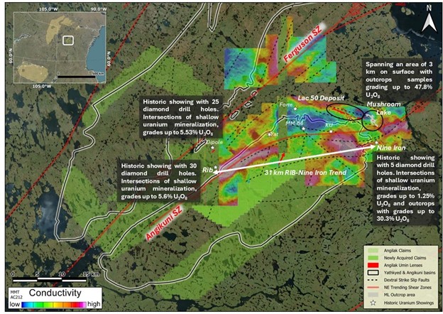
Figure 1: Plan Map detailing Lac 50 Deposit location with the Angilak Uranium Project
After acquiring the Project in March, 2024, the Company commenced its maiden exploration program which comprised three phases: Phase I - diamond drilling, Phase II - Surficial mapping and sampling, and Phase III - Geophysics.
Phase I - Between early June and late August, the Company completed 25 diamond drill holes comprising ~10,000 m. The drilling Phase of the campaign focused in and around the Lac 50 Deposit area, designed to explore the envelop of mineralization. The program proved extremely successful, with 100% of the drill holes intersecting uranium mineralization. Assay results are highlighted by grades of up to 5.85% U3O8 over 0.5 m.
Phase II - Surficial mapping was completed by late August. The mapping program successfully identified numerous additional high-grade uranium outcrops on surface and further outlined the Mushroom Lake Outcrop. Mushroom Lake is a 3 km area just to the north of the Lac 52 trend within the Lac 54 trend, with previously identified historic outcrop samples grading up to 47.8% U3O8.
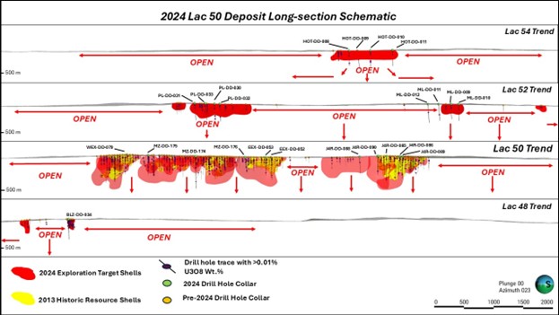
Figure 2: 2024 Lac 50 Deposit Long-section Schematic
Phase III - Geophysics was completed by late September 2024 and utilized an Airborne Mobile MagnetoTellurics ("MMT") survey totaling 5,946-line kilometres. The survey covers the northern half of the Angilak Project (Figure 1) - representing approximately 85% of the original project area, pre-2024 staking - inclusive of the Lac 48, 50, 52, and 54 mineralized trends (known as the "Lac 50 Deposit" area), as well as the eastern, western, and northern margins of the Angikuni Basin.
Results from the MMT survey confirm the depth extent of the prospective conductive horizons that host uranium mineralization at the Lac 50 Deposit and Nine Iron Discovery (Figure 1). At the Lac 50 Deposit the survey indicates that the prospective conductive horizons extend to approximately 1 km depth, while at Nine Iron Discovery the prospective horizons extend to approximately 800 m depth. At both areas the results demonstrate the potential for mineralization to extend well beyond the current envelops of mineralization. Additionally, along the western margin of the Angikuni Basin a 31 km conductive trend - significantly more conductive than Lac 50 and Nine Iron - has been identified. During the late 1970's several rounds of exploration took place along the Western Margin Trend ("WMT"), inclusive of diamond drilling, trenching and soil sampling, which resulted in the discovery of numerous uranium showings, including Rib and Yat.
At the Rib Discovery - located ~30 km southwest of the Lac 50 Deposit, situated along the western margin of the Angikuni Basin - early exploration programs were conducted by Noranda Exploration Company ("Noranda"). Between 1977 and 1979 Noranda completed 30 diamond drill holes at the Rib Discovery intersecting Athabasca Basin style unconformity alteration, structure, and lithologies associated with shallow (
The views and opinions expressed herein are the views and opinions of the author and do not necessarily reflect those of Nasdaq, Inc.

